


U.S. Expands Territory by 1 Million Square Kilometers—Claims Ocean Floor Rights

In a move that has caught global attention, the United States expanded its borders by a staggering 1 million square kilometers last year—but not through land. Instead, the U.S. has laid claim to vast stretches of ocean floor surrounding its shores! Dive into the details of how this bold expansion is reshaping international waters and what it means for future territorial rights.
The United States expanded by 1 million square kilometers last year.
To put this into perspective, 1 million square kilometers is roughly twice the size of Spain.
However, this expansion of the U.S. isn’t due to geographic reasons, as you might assume.
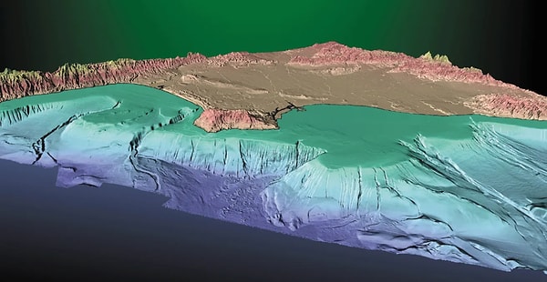
Instead, the U.S. began claiming rights over the seabed territories surrounding its oceans. According to IFL Science, countries can claim rights over their continental shelves under international law. By doing so, they can manage and utilize the resources found on these continental shelves, which are defined as areas of the seabed surrounding large landmasses where the sea is relatively shallow compared to the open ocean.
So far, 75 countries around the world have defined their continental shelves.

These designated areas are known as the Extended Continental Shelf (ECS) and can stretch up to 230 miles beyond a country’s coastline. Until last year, however, the U.S. was not among the countries that had defined their continental shelves.
In late 2023, the U.S. announced its own ECS areas.

The reason the U.S. hadn’t done so earlier was due to the lengthy process of gathering geological data. Since 2003, the U.S. has been collecting geological data for 20 years and now claims to have ECS zones in seven offshore areas.
These ECS boundaries span the Arctic, the Atlantic, the Bering Sea, the Pacific, the Mariana Islands, and two areas in the Gulf of Mexico, covering a total of 1 million square kilometers.

However, the legality of the ECS is a matter of debate. For the ECS boundaries to be officially recognized, the U.S. must submit data and reports to the United Nations Convention on the Law of the Sea (UNCLOS). The catch is that, while the EU and 168 countries have ratified UNCLOS, the U.S. has not.
The U.S.'s new claims over maritime boundaries may lead to an international crisis.

However, the U.S. is particularly interested in utilizing the ocean floor of the Arctic for more mining, shipping, and fishing activities. Additionally, owning this area is considered crucial for the nation's security.
Keşfet ile ziyaret ettiğin tüm kategorileri tek akışta gör!
 Test
Test
 Gündem
 Magazin
 Video
Video


Send Comment