


The Highest Peaks in Turkey for Mountain Adventures


Below are Turkey's 10 highest mountains, along with a brief introduction to each, how to get there, climbing conditions, things to do, and practical notes. The best window for most summits opens during the summer season (July–September); in winter and spring, the risk of ice, wind and avalanches becomes more pronounced. Acclimatisation at high altitude, weather forecasting, permit processes and local guides are critical considerations. So, where are the best spots for mountain climbing in Turkey? What are the highest peaks in Turkey? Let's explore together!
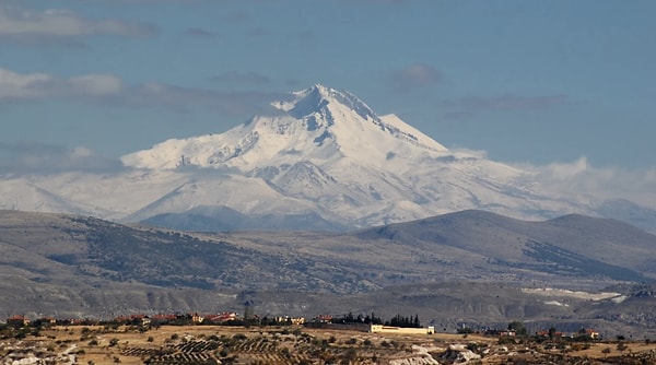
1. Mount Ararat – 5,137 m
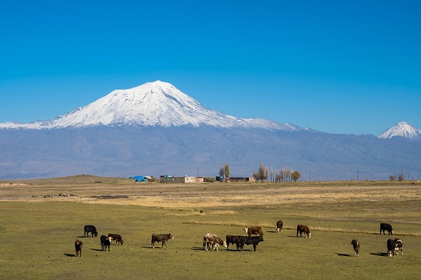
The highest point in Turkey, this stratovolcano rises between the provinces of Iğdır and Ağrı. It is characterised by broad slopes, hardened snow and ice in the upper sections, and a frozen layer around the summit for most of the year.
How to get there: Doğubayazıt is the most common starting point. The most convenient access is by road via Iğdır or Van to Doğubayazıt. Periodic permit notifications and guided climbing requirements may apply upon entering the region; current procedures should be confirmed with local authorities and clubs before travelling.
Climbing and season: The classic route is from the south face; typically, 2 or 3 camps (at approximately 3,200 m and 4,200–4,300 m) are set up, and the summit day is planned with acclimatisation tours. The most productive period is July–September; spring and winter require serious experience and full winter equipment due to wind and storms.
Things to do: In addition to the summit climb, high-altitude camping, photography and trekking on wide plateaus. Historical and cultural discoveries around Doğubayazıt (such as Ishak Pasha Palace) can be considered for day trips.
Note: Cold management above 5,000 metres, crampons, ice axes and storm window monitoring are critical. Group coordination and camp logistics are key to success.
2. Cilo Mountain / Uludoruk (Reşko) – 4,135 m
The highest peak of the Cilo-Sat range in Hakkâri, Uludoruk is a serious mountaineering destination with its rugged topography, glacial remnants and steep ridges.
How to get there: The most practical access is via the Hakkâri–Yüksekova route. Security and permit requirements in the region may vary seasonally; it is advisable to contact local authorities and mountaineering clubs before planning.
Climbing and season: Late summer offers more stable weather; late spring–early summer may see risks of hard snow and rockfall. Routes can be technical; experienced teams familiar with solid rock and snow-ice transitions are preferred.
Things to do: High-altitude camping, wildlife photography, and walks around the Sat Lakes.
Note: A helmet, helmeted descent safety equipment, and fitness suitable for variable weather and long approach stages are essential.
3. Mount Süphan – 4,058 m
Rising on the Bitlis/Van border north of Lake Van, this broad volcanic massif is a popular high-altitude acclimatisation destination, offering spacious base camp areas and panoramic views.
How to get there: The most common starting point is Adilcevaz and the surrounding villages, accessible by road from Van or Bitlis.
Climbing and season: In summer, the summit is usually reached with a single camp + night hike. Wind and hard ground may be encountered at higher altitudes; in winter, ice/snow conditions are prominent.
Things to do: Camping with views of Lake Van, sunset photography, hiking in the surrounding pastures.
Note: Route tracking (GPS/map-compass) is important to avoid getting lost on the wide slopes; plan ahead for water supply before camping.
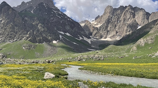
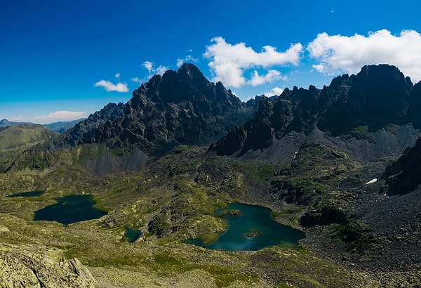
4. Kaçkar Mountain – 3,937 m
The most famous peak of the Black Sea region, located within Kaçkar Mountains National Park, is unique for its granite ridges, glacial lakes and highland culture.
How to get there: Yukarı Kavrun plateau on the Rize–Çamlıhemşin side is the classic starting point. An alternative approach is via the Barhal–Olgunlar villages route from Artvin/Yusufeli. Access is by road from Trabzon or Rize-Artvin airports.
Climbing and season: The best time is July–September; fog and rain change rapidly in the Black Sea region. On the classic route, rock-scree sections and short snow/ice crossings may be encountered depending on the season.
Activities: Trekking between mountain pastures, hiking to glacial lakes, camping, and wildlife observation.
Note: Layered clothing, a waterproof outer layer, and good route knowledge are essential due to rapid weather changes.
5. Mount Erciyes – 3,916 m
This ancient stratovolcano rising south of Kayseri is Turkey's leading winter ski resort and an accessible destination for summer summit climbs.
How to get there: The Tekir Plateau and ski resort area can be reached quickly from Kayseri city centre; access via Kayseri Airport is convenient.
Climbing and season: Summer routes mostly pass through scree and rock sections; hard ground may be encountered at higher elevations. Technical difficulty increases in winter; wind and snowstorms are common.
Things to do: Skiing and snowboarding (winter), summit attempts in summer, cycling and hiking trails.
Note: Due to sudden weather changes and the risk of rockfall, wearing a helmet and developing the habit of leaving early are important.
6. Lesser Ararat – 3,896 m
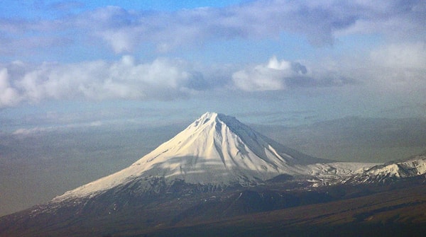
A secondary peak to the east of Greater Ararat, notable for its steeper conical shape. Environmental conditions and procedures may be similar to those for Greater Ararat.
How to get there: Access via the Doğubayazıt–Iğdır route; permit/guide requirements may vary from time to time.
Climbing and season: Steep slopes and wind effects can be serious even in summer. Helmets, walking sticks and crampons are required depending on the season due to the terrain and slope.
Things to do: It is an area for intensive training and technical climbing practice for teams attempting the summit.
Note: More compact surfaces increase the risk of falling; team coordination and mastery of fall arrest techniques are required.
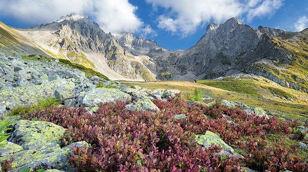
7. Kızılkaya – ≈3,776 m (Aladağlar)
The highest point of the Aladağlar, with its limestone walls and wide valleys in the Niğde–Adana–Kayseri triangle, is Turkey's classic mountaineering laboratory.
How to get there: Access to the Sokullupınar and Yedigöller campsites via Çamardı–Çukurbağ is common. Adana and Kayseri airports are logical entry points.
Climbing and season: Sturdy footwear and helmets are mandatory on rocky sections in summer; snow-ice combinations in winter require additional technical equipment.
Things to do: Long ridge walks, multi-day camping, rock climbing training, and combined programmes with other Aladağlar peaks in the vicinity.
Note: Navigation and water logistics are important; the temperature difference between day and night is high in summer.
Source: By Uefeyik
8. Demirkazık – 3,756 m (Aladağlar)
One of the symbols of mountaineering in the country with its sharp pyramidal silhouette. It offers options suitable for all levels with its classic and technical wall routes.
How to get there: Similar logistics to Kızılkaya; Emli Valley, Cımbar Pass and Sokullupınar region are common starting points.
Climbing and season: Classic summer routes mostly involve sections where hands are used on rock; in winter, technical snow-ice and mixed terrain are encountered.
Things to do: Summit climb, rock climbing practice, night sky photography, and walks in the surrounding highlands.
Note: It is advisable to wear a helmet to protect against falling rocks and to carry a topo/GPX for route verification.
Source: Zeynel Cebeci
9. Emler (Engin Tepe) – 3,723 m (Aladağlar)
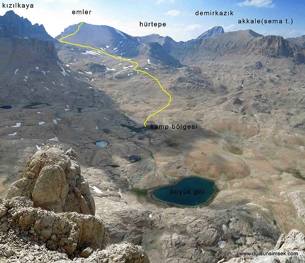
One of the most accessible 3,700+ m targets in the Aladağlar. Long walks and wide slopes provide a balanced challenge for those seeking new altitude experiences.
How to get there: Access via the Emli Valley or Yedigöller Plateau using a camp-summit approach.
Climbing and season: In summer, the route is more hike-oriented due to low snow cover; icy terrain may be encountered in spring–winter.
Things to do: Ideal location for camping and trekking around Yedigöller, photography, and multi-peak days.
Note: Speed management on wide slopes and balancing sun and wind exposure (hat, buff, sunscreen) are important.
Source: Dursun Şimşek
10. Verçenik – 3,710 m (Kaçkar Range)
Verçenik, located east of the Kaçkar massif, is visually and technically rewarding with its lakes, ridge passes and granite blocks.
How to get there: Approach via mountain roads from the Rize side; the final section of the route is mostly on foot. Road connections are available from Trabzon or Rize-Artvin airports.
Climbing and season: Weather is more stable in late summer; the possibility of fog, rain and hail should always be taken seriously.
Things to do: Lake-crossing trekking, camping and photography; different ridge routes can be attempted depending on experience.
Note: The Black Sea climate changes rapidly; maintaining route-weather compatibility is crucial for success.
Source: Macerita
Keşfet ile ziyaret ettiğin tüm kategorileri tek akışta gör!
 Test
Test
 Gündem
 Magazin
 Video
Video


Send Comment