


Giant Lake That Feeds Farmlands Vanishes Completely From the World Map


Extreme drought and early snowmelt have dragged the Elephant Butte Reservoir, the lifeline of agriculture in the US states of New Mexico and Texas, to its lowest level in history. The giant lake, which could be distinctly seen from space in 1962, has almost completely dried up as of July 2026, dwindling to a mere 1.4% of its capacity.


In 1962, astronaut John Glenn, while orbiting the Earth, drew attention to a massive irrigation valley, striking in its greenery against the desert, located to the northwest of El Paso, Texas.
The artificial lakes constructed along the Rio Grande River afforded the cultivation of alfalfa, cotton, onions, walnuts, and the famous Hatch green chili in the arid region.
However, abnormal drought conditions that have been intensifying in recent years in the Rio Grande basin have completely depleted the water resources. The earliest snowmelt recorded in the Southern Rocky Mountains in 2026 escalated the water crisis in the region to catastrophic levels.
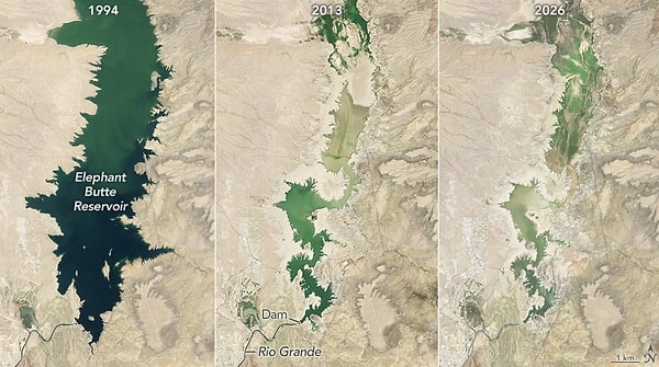
Elephant Butte Reservoir, the largest reservoir in New Mexico, is facing the most severe drought seen since 1971. According to NASA satellite images:
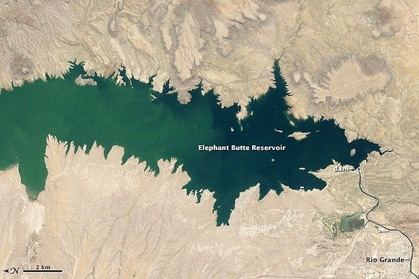
June 2, 1994: The lake was almost at full capacity.
July 8, 2013: During another drought, the annual lowest level was recorded at 2.9%.
July 27, 2026: The water quantity in the lake plummeted to a record low of 1.4% capacity.
As a result of the extreme drawdown, the lake's shorelines were coated with sediment and debris, rendering the boat ramps in the State Park unusable. It was reported that the lake began to refill slowly after the withdrawal of water for agricultural irrigation was halted on July 28, 2026.
The prolonged drought is compelling producers in both New Mexico and Texas to be more meticulous in their planning of underground and surface water usage.
NASA's Western Water Action Office (WWAO) has implemented advanced technology solutions to support regional water managers:
Real-Time Tracking: Researchers are providing real-time data to the Elephant Butte Irrigation District using satellite models that contain soil moisture and evaporation data.
Groundwater Monitoring: Through systems that combine water surface heights with drone and field data, the impact of groundwater pumping on the flow of the Rio Grande is being monitored, managing water rights accordingly.
Future Forecasts: NASA scientists are developing data-driven tools to predict the future water availability of the Upper Rio Grande as part of federal studies.
Keşfet ile ziyaret ettiğin tüm kategorileri tek akışta gör!
 Test
Test
 Gündem
 Magazin
 Video
Video



Send Comment